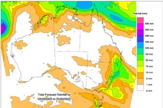
“Stretching from about the Illawarra [region to] around... Moreton Island in Queensland, there’s about 150mm that could be seen over the next week.”
The new weather system comes as a result of a cold front sitting over the Nullarbor Plain in South Australia on Tuesday, which will eventually make its way to Sydney late Wednesday.

Around 150mm of rain is expected to hit Sydney over the next seven days.Credit:Bureau of Meterology
The weather event will begin moving through Sydney on Wednesday afternoon, bringing up to 10mm of rain to the city centre.
On the coast, 20mm of rain is predicted for Bondi on Thursday, 40mm on Friday, 20mm on Saturday and 25mm on Sunday.
Residents of the flood-ravaged Northern Rivers have also been warned there is a chance of flash flooding later this week, an unwelcome event as residents continue the mammoth clean-up.
Weatherzone meteorologist Ben Domensino said while it would be a few days before weather models could provide a clearer picture, more rain was expected as a system of cool air in the upper atmosphere moved over eastern Australia from Thursday.

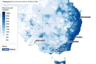
Root zone soil moisture on March 20, 2022. The root zone is defined as the top 1 metre of the soil profileCredit:Bureau of Meteorology via Weatherzone
“That upper trough may develop into an upper low, which is a similar type of system that underpinned the rain event [a few weeks ago],” he said.
“It’s hard to know exactly how the weather will respond to the upper low as it moves through – it is a dynamic weather system and the position of upper low and its strength will impact where the heavy rainfalls are.
“At this stage, more rain is likely over recently flood-affected areas, especially in NSW.”
Meanwhile, the wet weather looks set to linger until later this year with trade winds still stronger than average in the western Pacific, delaying the weakening of the weather system.
Modelling by the National Oceanic and Atmospheric Administration (NOAA) shows a third La Nina or a neutral phase could be possible next summer. Both the El Nino and La Nina are ends of a weather spectrum, with “neutral” sitting in the middle of the two. They are collectively known by scientists as the El Nino-Southern Oscillation (ENSO).
Mr Domensino said the NOAA model was just one that meteorologists used to predict climate drivers with both the Australian and European models showing a neutral phase was more likely. He added that it was difficult to predict the ENSO pattern, but that the models would be more reliable after winter.
“The reliability of models during the Southern Hemisphere’s autumn is very low. That means that anything the models are saying for next summer should be taken with a grain of salt,” he said.
The Morning Edition newsletter is our guide to the day’s most important and interesting stories, analysis and insights. Sign up here.


 Add Category